
Japan geography describes a volcanic island nation shaped by tectonic activity along the Pacific Ring of Fire. Japan consists of 4 main islands and thousands of smaller ones. It sits where several tectonic plates meet, which explains frequent earthquakes and many active volcanoes.
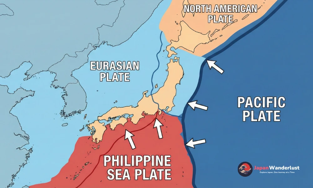
This structure comes from the interaction of the Pacific Plate, Philippine Sea Plate, Eurasian Plate, and North American Plate. Subduction zones along Japan’s eastern and southern edges drive seismic movement and magma formation. These forces create mountain ranges, limit flat land, and form deep ocean trenches.
Many sources label Japan as simply “earthquake-prone” without explaining the cause. While tremors are common, not all earthquakes cause damage, and volcanic activity follows monitored patterns. Ignoring plate boundaries, fault systems, and monitoring networks leads to shallow or misleading conclusions.
Organizations such as the Japan Meteorological Agency (JMA) and the United States Geological Survey (USGS) track seismic and volcanic activity across Japan. Peer-reviewed geological studies show that Japan is one of the most closely monitored tectonic regions worldwide, supported by dense sensor networks and long-term data.
Understanding Japan geography clarifies natural risks, land-use limits, and disaster preparedness policies. This knowledge helps readers interpret news reports, travel advisories, and hazard maps with confidence.
What Is the Geography of Japan?
Japan is an island nation in East Asia, located along the western edge of the Pacific Ocean. It lies off the eastern coast of the Asian continent and is separated by the Sea of Japan. The country stretches from north to south in a long, narrow arc, spanning multiple climate zones.
Geographically, Japan consists of four main islands and thousands of smaller ones. Most of the land is mountainous, with limited flat plains concentrated near the coast. Japan sits along active tectonic plate boundaries, which shape its landforms, coastlines, and overall natural structure.
This combination of island location, steep terrain, and surrounding seas influences how Japan looks and functions. It affects where people live, how cities grow, and how transport networks connect different regions.
What Is Japan’s Physical Geography?
Japan’s physical geography is defined by mountain ranges, long coastlines, and its location on active tectonic plates. The land rises quickly from the sea, creating steep interiors and narrow plains. Most population centers sit near the coast, while higher elevations dominate inland areas.
Core physical elements
- Mountains covering most of the interior
- Extensive coastlines along the Pacific Ocean and the Sea of Japan
- Volcanic arcs formed by tectonic plate movement
- Short rivers flowing from mountain areas directly to the sea
What Are Japan’s Major Landforms and Physical Features?
Japan’s major landforms reflect its island setting and active geology. The country transitions quickly from mountains to coast, creating a clear physical structure across the islands.
- Mountain ranges: Stretch across much of the main islands and form the country’s geographic backbone, limiting large inland plains.
- Coastal plains: Small, low-lying areas near the sea where major cities, ports, and transport networks are concentrated.
- Volcanoes: Distributed across the islands, including prominent peaks that shape regional landscapes.
- Rivers: Short and fast-flowing, running from mountainous areas directly toward the coast.
- Islands and peninsulas: Create an irregular shoreline with bays, inlets, and natural harbors.
Together, these physical features explain why Japan has compact cities, limited flat land, and strong connections between mountains, rivers, and the surrounding sea.
What Is Japan’s Terrain Like?
Japan’s terrain feels steep, compact, and varied. Mountains often rise immediately behind cities, while flat land appears in small, fragmented areas along the coast. Travel frequently involves tunnels, bridges, and winding routes instead of long, open plains.
In daily life and development, this terrain supports dense urban centers, efficient public transport, and careful land use. Cities tend to grow upward rather than outward, while rural areas remain closely connected to hills, forests, and nearby coastal waters.
Where is Japan located?
Japan’s location plays a crucial role in its historical development, economic success, and cultural identity. Understanding where Japan is situated helps explain its unique position as an island nation and its relationships with neighboring countries. Let’s explore Japan’s precise location, its neighboring nations, and the composition of its territory.
Which Countries are Near Japan?
Japan shares maritime borders with several Asian nations, creating a complex network of international relationships. Here are Japan’s primary neighboring countries:
- South Korea: Located approximately 200 kilometers across the Korea Strait from Japan’s western coast
- China: Situated about 800 kilometers west of Japan across the East China Sea
- Russia: Positioned to the north, with Hokkaido being closest to Russia’s Sakhalin Island
- Taiwan: Located around 1,100 kilometers south of Japan’s southernmost islands
These proximity relationships have historically influenced Japan’s trade routes, cultural exchanges, and diplomatic relations throughout Asia.
What is Japan’s Geographical Location?
Japan lies between 24° and 46° north latitude and 122° to 146° east longitude, positioning it firmly in the temperate zone of the Northern Hemisphere. This geographical position places Japan along the eastern edge of Asia, stretching from the Sea of Okhotsk in the north to the East China Sea in the south.
The country’s strategic location has historically made it an important hub for Pacific trade routes and continues to provide significant advantages for international commerce. Japan’s position also places it along the Pacific Ring of Fire, influencing its geological characteristics and climate patterns.
What is the Total Land Area of Japan?
Japan covers a total area of 377,975 square kilometers (145,937 square miles). To put this in perspective, here’s how Japan compares to other countries:
| Country | Land Area (km²) |
|---|---|
| Japan | 377,975 |
| Germany | 357,022 |
| Norway | 385,207 |
Despite its relatively modest size, Japan efficiently utilizes its territory to support the world’s third-largest economy and a population of over 125 million people.
What are the Four Main Islands of Japan?
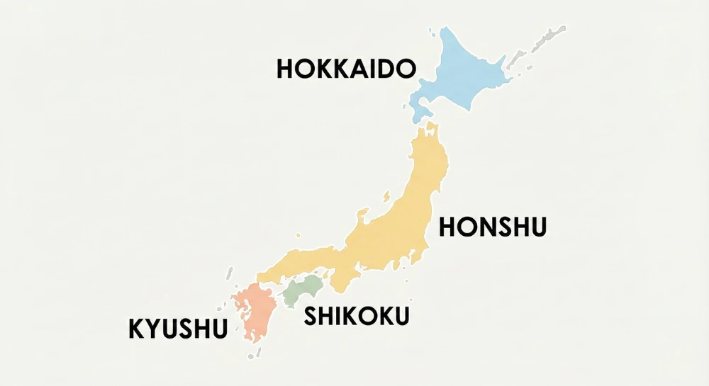
Japan’s territory consists primarily of four major islands:
- Honshu: The largest and most populous island, home to major cities like Tokyo, Osaka, and Kyoto
- Hokkaido: The northernmost main island, known for its natural beauty and winter activities
- Kyushu: The southernmost of the four main islands, featuring active volcanoes and historic ports
- Shikoku: The smallest of the main islands, famous for its Buddhist pilgrimage routes
Together, these four islands account for approximately 97% of Japan’s total land area, with Honshu alone comprising about 60% of the country’s territory. Each island contributes uniquely to Japan’s cultural and economic landscape, creating a diverse yet unified nation.
To learn more about the Japan region classifications, check out this detailed guide.
What are Japan’s Key Geographic Features?
Japan’s unique geographic features have profoundly shaped its culture, economy, and way of life. As an archipelago stretching over 3,000 kilometers, Japan’s landscape is characterized by dramatic mountains, winding rivers, and an extensive coastline that has influenced everything from traditional art to modern industry. These natural landmarks and geographic elements continue to play a vital role in Japanese society, affecting settlement patterns, resource utilization, and cultural development.
Why does Japan Have So Many Mountains?
Japan’s mountainous terrain is a direct result of intense tectonic activity at the intersection of multiple tectonic plates. The collision between the Pacific Plate and the Eurasian Plate has created significant uplift, forming the country’s characteristic mountainous landscape. This ongoing geological process has created dramatic mountain ranges, including the Japanese Alps, which run through the center of Honshu island.
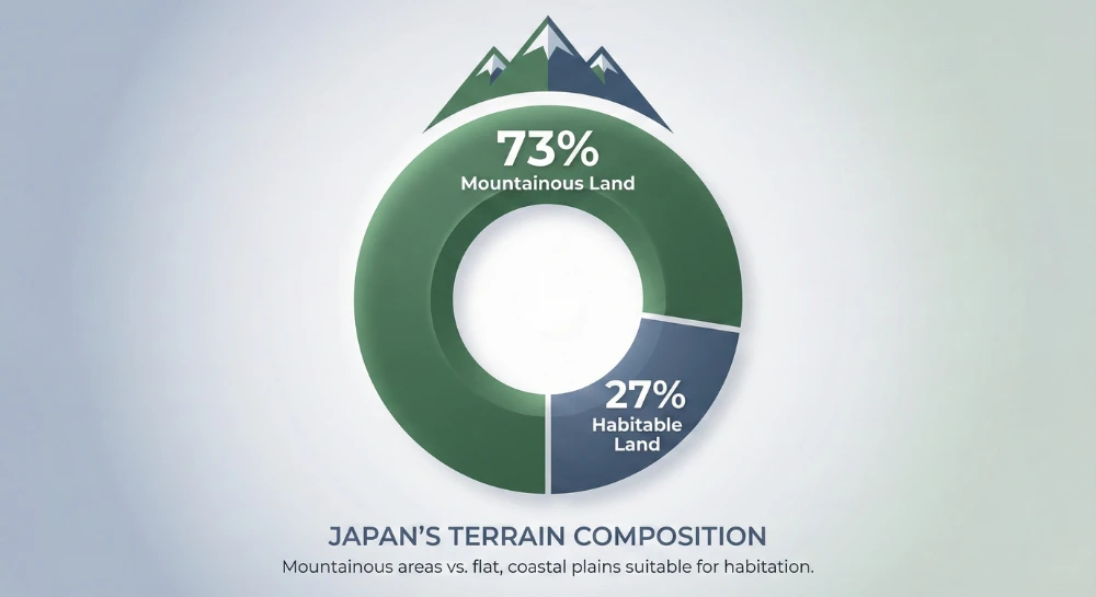
Mount Fuji, Japan’s most iconic peak, stands as a testament to this volcanic activity. Rising 3,776 meters above sea level, it represents one of the many volcanoes formed by tectonic forces. Approximately 73% of Japan’s landmass consists of mountains, making it one of the most mountainous developed nations in the world.
What are Japan’s Key Natural Resources?
Despite limited land area, Japan possesses diverse natural resources that have historically supported its development. Marine resources represent one of the country’s most valuable assets, with rich fishing grounds in surrounding waters supporting one of the world’s largest fishing industries. The country’s extensive forests, covering about 67% of the land, provide valuable timber resources and support biodiversity.
Mineral resources, though limited, include deposits of zinc, lead, and copper. However, Japan must import most of its raw materials for industrial production. Here are the key natural resources:
- Marine resources: Fish, seaweed, shellfish
- Forest resources: Timber, bamboo, forest products
- Mineral resources: Limestone, sulfur, small deposits of precious metals
- Renewable resources: Geothermal energy, hydroelectric potential
What are Japan’s Most Famous Natural Landmarks?
Mount Fuji stands as Japan’s most recognized natural landmark, attracting millions of visitors annually and holding deep cultural and spiritual significance. The mysterious Aokigahara Forest, located at Mount Fuji’s base, is known for its dense vegetation and unique ecological features. The forest’s volcanic soil creates unusual magnetic conditions that have contributed to its mystical reputation.
The Shiretoko Peninsula in Hokkaido represents one of Japan’s most pristine natural areas, recognized as a UNESCO World Heritage site. Its dramatic coastline, diverse wildlife, and pristine forests showcase Japan’s natural beauty. Okinawa’s coral reefs present another significant landmark, hosting diverse marine ecosystems and attracting tourists from around the world.
What are the Major Rivers and Lakes in Japan?
The Shinano River, Japan’s longest river at 367 kilometers, flows through multiple prefectures and plays a crucial role in hydroelectric power generation and agriculture. The Tone River system serves as a vital water source for the Greater Tokyo Area, demonstrating the essential role of rivers in supporting urban development.
Lake Biwa, Japan’s largest freshwater lake, holds both historical and ecological significance. Located in Shiga Prefecture, it provides water for millions of people and supports unique ecosystems. The lake has influenced local culture, appearing in countless poems, paintings, and traditional stories throughout Japanese history.
| Name | Type | Length/Size | Role |
|---|---|---|---|
| Shinano River | River | 367 km | Hydroelectric power, agriculture |
| Tone River | River | 322 km | Water source for urban development |
| Lake Biwa | Lake | 670 km² | Water supply, cultural and ecological importance |
These geographic features collectively form the foundation of Japan’s natural heritage, influencing everything from traditional customs to modern infrastructure development. Their preservation remains crucial for maintaining both ecological balance and cultural identity in contemporary Japan.
What is the Climate of Japan?
Japan’s climate is a fascinating interplay of geographical location and natural forces, characterized by its distinct four seasons and temperate nature. Located off the eastern coast of Asia, stretching from approximately 45°N to 24°N latitude, Japan experiences a primarily temperate climate influenced by its position between the Asian continent and the Pacific Ocean. This unique geographical setting, combined with the country’s varied topography, creates diverse weather patterns across its archipelago.
What are the main climate zones in Japan
Japan’s climate diversity is reflected in its five distinct climate zones, each with unique characteristics. The northernmost island of Hokkaido experiences a subarctic climate with long, cold winters and mild summers.
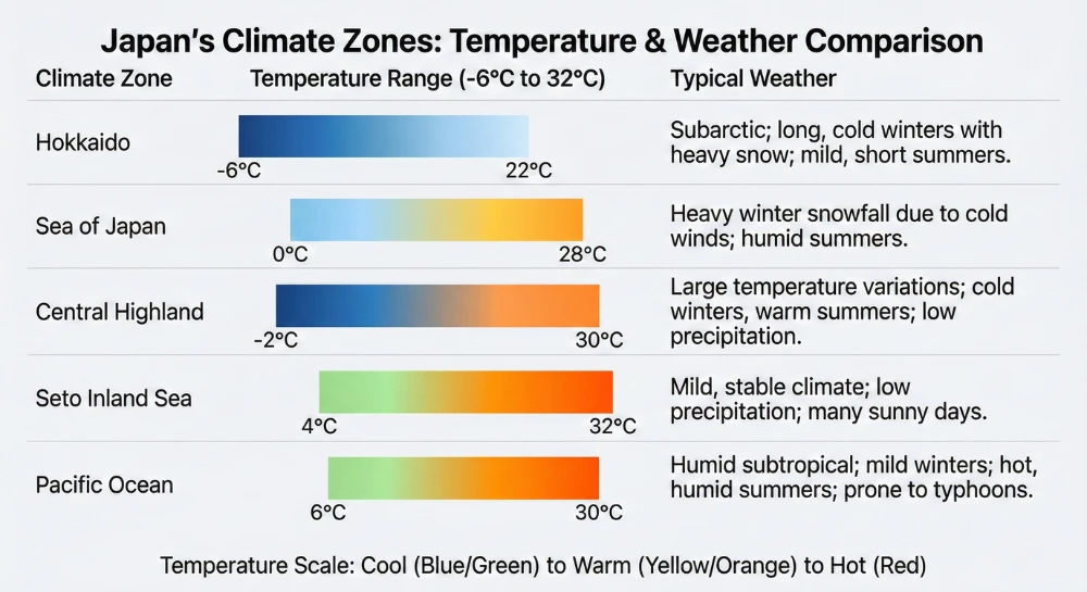
The Sea of Japan zone receives heavy snowfall in winter due to cold winds from Siberia picking up moisture over the warm currents. The Central Highland region, dominated by mountainous terrain, sees significant temperature variations between seasons and altitudes.
| Climate Zone | Temperature Range | Annual Precipitation |
|---|---|---|
| Hokkaido | -6°C to 22°C | 1,100mm |
| Sea of Japan | 0°C to 28°C | 2,400mm |
| Central Highland | -2°C to 30°C | 1,800mm |
| Seto Inland Sea | 4°C to 32°C | 1,200mm |
| Pacific Ocean | 6°C to 30°C | 1,600mm |
How does Japan’s Geography Influence its Weather Patterns?
Japan’s mountainous terrain plays a crucial role in shaping its weather patterns. The Japanese Alps, running through the center of Honshu, create a dramatic divide between the Sea of Japan and Pacific coasts. This geographical feature leads to the phenomenon known as “yamase,” where the mountains block cold air masses, resulting in distinct weather patterns on either side.
The country’s proximity to the ocean significantly influences its climate, particularly regarding typhoons and precipitation patterns. The warm Kuroshio Current along the Pacific coast and the cold Oyashio Current near Hokkaido create conditions that can intensify weather systems.
During winter, the interaction between cold continental air masses and the warm Sea of Japan results in heavy snowfall along the western coast, particularly in regions facing the Sea of Japan.
How Do Seasonal Changes Affect Japan’s Geography?
Japan’s seasonal transitions dramatically transform its landscapes throughout the year. Spring brings the famous sakura season, when cherry blossoms sweep across the country in a pink wave from south to north. This natural phenomenon, closely monitored through cherry blossom forecasts, marks one of Japan’s most celebrated seasonal changes.
Summer introduces the challenging tsuyu (rainy season) followed by intense heat and humidity, often accompanied by typhoons along the Pacific coast. Autumn paints the landscape in vibrant colors during the koyo (autumn foliage) season, with maple and ginkgo trees creating spectacular displays in mountainous regions. Winter transforms Japan’s geography most dramatically, especially in regions like Hokkaido and the Japan Sea coast, where heavy snowfall creates opportunities for winter festivals, such as the famous Sapporo Snow Festival.
These seasonal changes not only influence the physical landscape but also play a crucial role in Japanese culture, with numerous festivals and traditions timed to coincide with specific seasonal phenomena. From hanami (cherry blossom viewing) parties in spring to momiji-gari (autumn leaf viewing) excursions, the Japanese calendar is deeply intertwined with these natural cycles.
Why is Japan Geologically Active?
Japan’s remarkable geological activity stems from its unique position in one of Earth’s most dynamic tectonic regions. Situated at the intersection of multiple tectonic plates along the Pacific Ring of Fire, Japan experiences frequent seismic events, volcanic eruptions, and ongoing geological transformations that shape its landscape. This geological dynamism has profoundly influenced Japanese culture, architecture, and disaster preparedness strategies.
Is Japan Part of the Ring of Fire?
Yes, Japan is an integral part of the Pacific Ring of Fire, a horseshoe-shaped zone of intense geological activity that spans approximately 40,000 kilometers around the Pacific Ocean. This region accounts for roughly 90% of the world’s earthquakes and houses about 75% of Earth’s active volcanoes. Japan shares this dynamic geological heritage with other Ring of Fire countries, including Indonesia, Chile, and the western United States.
The country’s position along this volatile zone results from its location at the junction of four major tectonic plates: the Pacific, Philippine Sea, Eurasian, and North American plates. This convergence creates a complex network of subduction zones, where oceanic plates dive beneath continental plates, generating significant geological activity.
Why Does Japan Experience Frequent Earthquakes?
Japan’s high earthquake frequency is directly linked to its position above multiple tectonic plate boundaries. The Pacific Plate subducts beneath the Japanese archipelago at a rate of approximately 8-9 centimeters per year, creating enormous pressure that periodically releases as seismic activity. This constant movement along fault lines results in thousands of detectable earthquakes annually, ranging from minor tremors to major seismic events.
This constant movement along fault lines not only results in thousands of detectable earthquakes annually, ranging from minor tremors to major seismic events, but also has the potential to trigger destructive Japanese tsunamis, which pose significant risks to coastal areas.
Historical examples demonstrate the intensity of Japan’s seismic activity, with the 1923 Great Kanto Earthquake standing as a significant example. This devastating 7.9 magnitude earthquake caused widespread destruction in Tokyo and Yokohama. More recently, the 2011 Tohoku earthquake (magnitude 9.0) triggered a massive tsunami and highlighted the ongoing seismic risks facing the nation.
How Many Active Volcanoes Are in Japan?
Japan hosts 111 active volcanoes, representing about 7% of the world’s active volcanoes. These geological features are monitored constantly by the Japan Meteorological Agency due to their potential impact on surrounding communities. Several of these volcanoes have become iconic landmarks and popular tourist destinations, while also serving as valuable sources of geothermal energy.
Notable active volcanoes in Japan include:
- Mount Aso (Kyushu) – Japan’s largest active volcano and one of the world’s largest calderas
- Sakurajima (Kagoshima) – One of Japan’s most active volcanoes, with regular small eruptions
- Mount Fuji (Honshu) – Japan’s highest peak and most famous volcano, though currently dormant
- Mount Asama (Honshu) – One of the most active volcanoes on Honshu island
These volcanic formations contribute significantly to Japan’s geothermal energy production and hot spring (onsen) culture, demonstrating how the country has adapted to and benefited from its geological activity.
Japan’s position in this geologically active region has shaped not only its physical landscape but also its technological advancement in earthquake prediction, building design, and disaster preparedness, making it a world leader in managing geological risks while harnessing the benefits of its unique geological setting.
How Does Japan Prepare for Earthquakes and Tsunamis?
Japan has developed one of the world’s most advanced earthquake and tsunami preparedness systems, learning from past disasters like the 2011 Tohoku earthquake. The country’s comprehensive approach combines cutting-edge technology, public education, and strict building codes to protect its citizens from these natural hazards.
The nation’s early warning system uses a network of seismic sensors that can detect earthquakes before they strike populated areas. When these sensors detect seismic activity, including those near the Kuril Islands, they automatically trigger tsunami warnings through multiple channels: mobile phones, TV broadcasts, and public announcement systems. This gives people precious minutes to evacuate to higher ground or seek shelter in earthquake-resistant buildings.
Here are Japan’s key preparedness measures:
- Earthquake-resistant architecture and strict building codes
- Regular evacuation drills in schools and workplaces
- Public education programs about disaster response
- Clearly marked tsunami evacuation routes and shelters
- Emergency supply stockpiles in communities
- Advanced monitoring systems for seismic activity
The Japanese government also maintains disaster response centers that operate 24/7, ready to coordinate emergency services when earthquakes and tsunamis strike. These centers work alongside local authorities to ensure rapid response times and effective communication during crisis situations, making Japan a global leader in natural disaster preparedness.
What Makes Japan’s Geography Unique?
Japan’s unique geography sets it apart from other nations, creating a distinctive landscape that has profoundly shaped its culture, development, and way of life. From its densely forested mountains to its intricate coastlines, Japan’s geographic features present both challenges and opportunities for its inhabitants. Let’s explore the remarkable characteristics that make Japan’s geography truly unique.
Why is Japan more heavily forested than China?
Japan maintains an impressive 67% forest coverage, significantly higher than China’s 23%. This stark difference stems from several factors, including Japan’s strict forest conservation policies implemented since the Edo period (1603-1867). The country’s abundant rainfall and humid climate create ideal conditions for forest growth, while cultural values emphasizing harmony with nature have helped preserve these woodlands.
Unlike China’s rapid industrialization that led to extensive deforestation, Japan has managed to balance development with environmental preservation. The Japanese government’s sustainable forestry practices and the cultural significance of forests in Shinto religion have contributed to maintaining this high forest coverage. Additionally, Japan’s mountainous terrain makes many areas unsuitable for development, naturally protecting forest ecosystems.
What percentage of Japan’s land is habitable?
Surprisingly, only about 27% of Japan’s total land area is considered habitable. This limited space creates one of the world’s highest population densities in urban areas, with Tokyo-Yokohama ranking among the most densely populated metropolitan regions globally. The reason for this constraint lies in Japan’s mountainous topography, with roughly 73% of the land consisting of mountains and forests.
The concentration of people in habitable areas has led to innovative urban planning solutions and efficient use of available space. Most of Japan’s population resides in coastal plains and valleys, where cities have expanded vertically rather than horizontally. This unique distribution of habitable land has influenced everything from architecture to agricultural practices.
What are Some Interesting Geography Facts About Japan?
Japan’s geography contains fascinating features that showcase its unique position in the world:
- The country consists of 6,852 islands, though only 430 are inhabited
- Mount Fuji, Japan’s highest point, stands at 3,776 meters (12,388 feet)
- Japan’s coastline stretches for 29,751 kilometers (18,486 miles)
- Okinotorishima is Japan’s southernmost point, a tiny atoll crucial for territorial waters
- The country lies at the intersection of four tectonic plates, resulting in frequent seismic activity
- Japan experiences all four seasons distinctly due to its geographical position
What are the Main Ecosystems and Wildlife in Japan?
Japan’s diverse ecosystems support a rich variety of wildlife. The temperate broadleaf and mixed forests dominate the main islands, providing habitat for iconic species like the Japanese macaques, also known as snow monkeys. These remarkable primates are famous for bathing in hot springs during winter, demonstrating unique adaptive behaviors.
The Shiretoko ecosystem in Hokkaido represents one of Japan’s most pristine natural environments, where brown bears and red-crowned cranes thrive. Coastal areas support rich marine biodiversity, including various species of whales, dolphins, and endemic fish. Wetland ecosystems, though limited in size, play crucial roles in supporting migratory birds and unique amphibian species.
The country’s varied elevation zones create distinct habitats, from alpine meadows to subtropical forests in the southern islands. This range of ecosystems contributes to Japan’s high biodiversity despite its relatively small land area.
Japan’s geography combines mountainous terrain, extensive forests, limited habitable land, and diverse ecosystems to create a unique natural environment. These distinctive features have not only shaped the nation’s development but continue to influence modern Japanese society and culture, making it one of the world’s most fascinating geographical regions.
How Does Japan’s Geography Impact its People?
Japan’s unique geography has profoundly shaped its national identity, cultural development, and economic trajectory throughout history.
As an island nation positioned along the Pacific Ring of Fire, Japan’s geographical features – from its mountainous terrain to its extensive coastline – have created both opportunities and challenges that continue to influence every aspect of Japanese life.
Understanding the impact of geography on Japan helps explain many distinctive characteristics of Japanese society and its economic structure.
How has Japan’s Geography Shaped its Cultural and Economic Development?
Japan’s geographical isolation has played a pivotal role in forging its unique cultural identity. During the Edo period (1603-1867), this isolation was deliberately enhanced through the sakoku policy, which limited foreign contact and allowed Japanese culture to develop distinctively. This period of self-imposed isolation helped preserve and refine many traditional arts, customs, and social structures that remain influential today.
The nation’s island geography has also fostered a delicate balance between isolation and connectivity. While separated from mainland Asia, Japan’s strategic position along maritime trade routes has historically facilitated economic development and cultural exchange. This geographical duality helped Japan maintain cultural independence while selectively adopting and adapting foreign influences to suit its needs, a pattern that continues in modern times.
How Does Japan’s Coastline Shape its Economy and Culture?
Japan’s 29,751 kilometers of coastline has historically been crucial to its development, with major port cities like Yokohama, Kobe, and Osaka serving as vital economic hubs. These ports have facilitated international trade and helped establish Japan as a major maritime nation. The fishing industry, deeply embedded in Japan’s coastal economy, remains one of the world’s largest, contributing significantly to both the national economy and food security.
Culturally, the sea has profoundly influenced Japanese traditions and daily life. Coastal communities celebrate numerous maritime festivals (umi matsuri), while seafood plays a central role in Japanese cuisine. The cultural significance of the ocean is reflected in art, literature, and religious practices, demonstrating how deeply geography has influenced Japanese cultural identity.
How Does Japan’s Geography Contribute to its Vulnerability to Natural Disasters?
Japan’s location at the convergence of several tectonic plates makes it particularly susceptible to earthquakes and tsunamis. The devastating 2011 Tohoku earthquake and subsequent tsunami demonstrated this vulnerability, resulting in widespread destruction and the Fukushima nuclear disaster. The country’s mountainous terrain and position in the path of seasonal typhoons further increase its natural disaster risk.
These geographical challenges have shaped Japanese architecture, urban planning, and disaster preparedness. Communities have developed sophisticated early warning systems and building techniques, while traditional Japanese architecture incorporates features designed to withstand natural disasters. This resilience in the face of geographical challenges has become a defining characteristic of Japanese society.
What are the Economic Impacts of Japan’s Geography?
Japan’s geographical constraints have significantly influenced its economic development. With only about 12% of its land suitable for agriculture, Japan has had to innovate in farming techniques and rely heavily on food imports. This limited farmland has pushed the country toward industrial and technological development, leading to its emergence as a global economic power.
However, Japan’s geography also provides certain advantages. Rich fisheries support a robust fishing industry, while deep natural harbors facilitate international trade. The country’s mountainous terrain, while limiting agriculture, provides abundant hydroelectric power and supports tourism. These geographical factors have shaped Japan’s economic strategies and industrial focus.
How Does Japan’s Geography Affect Tourism?
Japan’s diverse geography creates year-round tourism opportunities. Mount Fuji, the nation’s iconic symbol, attracts millions of visitors each year. Thousands of onsen (natural hot springs) draw travelers seeking relaxation in geothermally heated waters. The country’s varied terrain supports both summer beach activities and winter skiing, which sustains a broad tourism base.
Seasonal geographic features create clear travel patterns throughout the year. Cherry blossoms in spring and colorful autumn foliage generate distinct tourism peaks. These seasonal changes, combined with coastlines, mountains, and rural landscapes, encourage repeat visits and support steady domestic and international travel. These geographic conditions also shape how visitors explore the country, which is why some travelers choose a Japan private tour to experience specific regions, seasons, and landscapes at their own pace.
Japan’s geography has played a direct role in shaping its national character. Mountainous terrain, limited arable land, and natural hazards have influenced settlement patterns, infrastructure planning, and economic strategy. The ongoing challenges and opportunities created by these geographic features continue to affect modern Japanese society, showing the long-term impact of physical geography on human activity.